Spotting small objects on the seafloor
A rock the size of a thumb will be visible on the seafloor when PhD candidate Ole Jacob Lorentzen has completed his work on designing the algorithms for images from Kongsberg Maritime’s HISAS sonar.
His PhD work at the Norwegian Defence Research Establishment (FFI) is about improving mapping in rugged terrain: “If the seafloor is relatively flat, we can do this quite well today, but if it is rough, it is much more difficult to make high-quality, high-resolution maps with ship- wrecks and other objects,” he says.
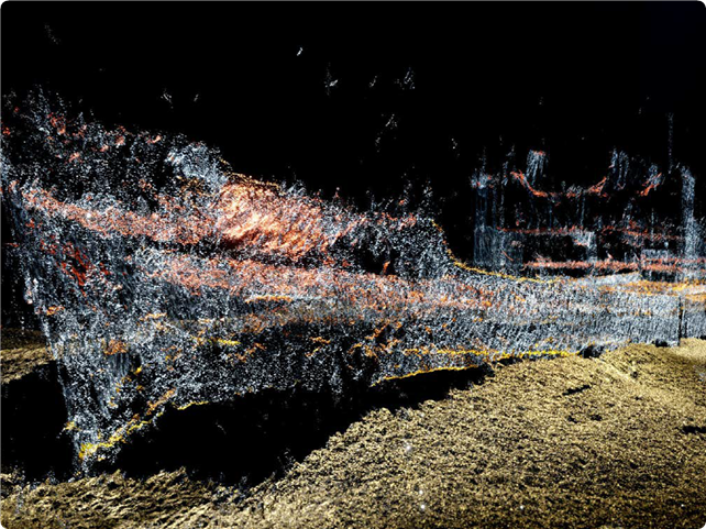
Lorentzen works on improving the computer-algorithms used for processing the images from synthetic aperture sonars (SAS) making the images more detailed. These sonars combine many acoustic pings to form an image with much higher resolution than conventional sonars. SAS can provide centimetre-resolution over a range of hundreds of metres on the seafloor. The sonar recordings come from the autonomous underwater vehicle HUGIN with the HISAS 1032, developed by FFI and Kongsberg Maritime. The sonar is 100 kilohertz, so this is high-frequency underwater sonar.
“The HISAS is an interferometric SAS with two horizontal receiver arrays and a vertical transmit array. This system transmits a wide beam filling a large area on the seafloor with sound,” Lorentzen explains.
Better depth maps
Lorentzen holds a master’s degree in informatics from the University of Oslo. He started his PhD at UiO two years ago and is set to complete it in three years as he also works part-time as a scientist at FFI.
One of the projects he has been working on is a method to extract information about the objects in the image to make an improved depth map. They use two vertically displaced images from the sonar to extract the 3D information:
“It is a black and white image, and I detect data points that should be together. If we do it correctly, it will give us a more correct depth map. It works very well.
Although it cannot work in all cases, it improves the result in many cases,” Lorentzen says.
Must get everything right
Lorentzen describes programming and data processing as having a million things to keep track of: “There is an infinite number of places where we can make slight improvements, and a few places where we can make bigger improvements. There are many things to be in control of, and it is a huge challenge, actually.”
“I love to do what I do, and the freedom to try out new things, new methods, to play around with things to get better results,” he adds.
Valuable for a range of purposes
High-resolution images of the seafloor are valuable for a variety of purposes. The technology is relatively new, and Lorentzen’s work is advancing it further.
“It is a step forward like most research, but also a quite important topic, especially in Norway where we have a lot of marine resources. FFI works closely together with Kongsberg Maritime and the Norwegian navy to improve the technology that is useful for all parties. I also do a lot of work with academic institutions like the universities in Oslo, Bergen, and Trondheim. We go on expeditions and work on data together.”
Amazing images
“I want to collaborate with applied fields and not only be in the signal processing bubble, which is one reason I work with Marine Archaeologist Øyvind Ødegård at NTNU. In Bergen, I work with people in geology,” says Lorentzen.
They are developing images from the seafloor at the Mid- Atlantic Ridge, where the continents are moving apart, and there is volcanic activity and fracturing.
“It’s not my field, but it’s so exciting to learn from the people working on it. And we get amazing images,” he says.
This article first appeared in the 2021 CIUS Annual Report.
